Rodgers et al. (2024)
WUS324: Multiscale Full Waveform Inversion Approaching Convergence Improves Waveform Fits While Imaging Seismic Structure of the Western United States
A. J. Rodgers, C. D. Doody, and Andreas Fichtner

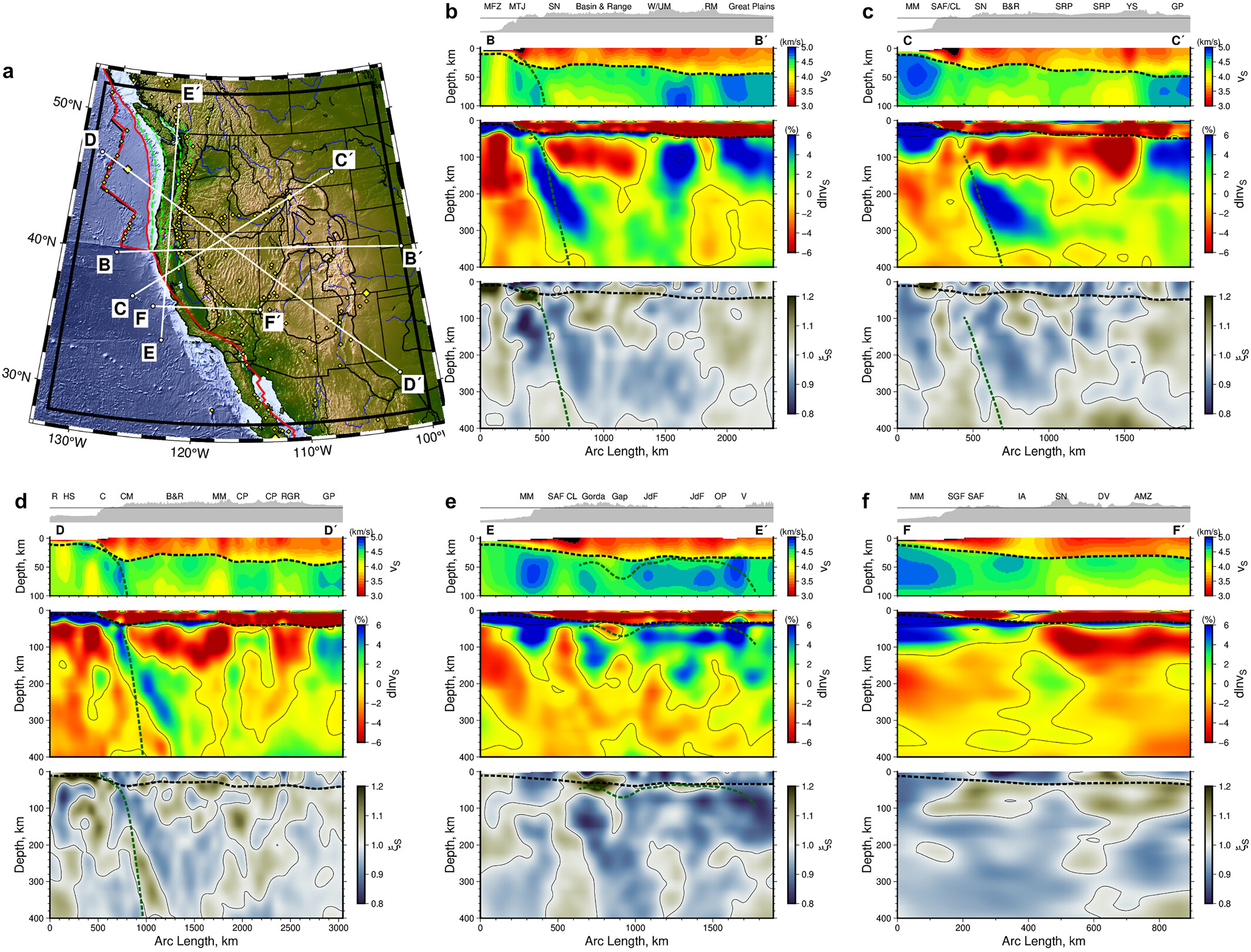
Figure 1:Cross-sections through the WUS324 model. (a) Map showing locations of cross-sections. Panels b–f show topography/bathymetry along the corresponding profile with absolute vS from the surface to 100 km depth, dlnvS and ξS from the surface to 400 km depth (top to bottom) with the Moho indicated by dashed black line and inferred Cascadia slab depths (Hayes et al., 2018) as green dashed lines. Note different length scales are used in each panel. (b) B–B’ transect with labeled features: Mendocino Fracture Zone (MFZ); Mendocino Triple Junction (MTJ); Sierra Nevada (SN); Wasatch/Uinta Mountains (W/UM) and Rocky Mountains (RM). (c) C–C’ transect with labeled features: Monterey Microplate (MM); San Andreas Fault/Clear Lake Volcanic Field (SAF/CL); Sierra Nevada (SN); Basin and Range (B&R); Snake River Plain (SRP); Yellowstone (YS) and Great Plains (GP). (d) D–D’ transect with labeled features: Juan de Fuca Ridge (R); Juan de Fuca Hotspot (HS); coast (C); Cascade Mountains (CM); Basin and Range (B&R); Mineral Mountains (MM); Colorado Plateau (CP) and Rio Grande Rift (RGR). (e) E–E’ transect with labeled features: Monterey Microplate (MM); San Andreas Fault (SAF); Clear Lake Volcanic Field (CL); Gorda slab (Gorda); slab gap (Gap); Juan de Fuca slab (JdF); Olympic Peninsula (OP) and Vancouver (V). (f) F–F’ transect with labeled features: Monterey Microplate (MM); San Gregorio Fault (SGF); San Andreas Fault (SAF); Isabella Anomaly (IA); Sierra Nevada (SN); Death Valley (DV) and amagmagtic zone (AMZ).
Summary
We report a new model of radially anisotropic crustal and upper mantle structure of the western United States (WUS324) obtained from full waveform inversion of earthquake data. We ran three multiscale inversion stages beyond model WUS256 (Rodgers et al., 2022, https://
Model Information
SUMMARY: Adjoint waveform tomography
MODEL TYPE: V, V, and density
MINIMUM LONGITUDE: -130
MAXIMUM LONGITUDE: -116
LONGITUDE RESOLUTION: 0.125
MINIMUM LATITUDE: 39
MAXIMUM LATITUDE: 52
LATITUDE RESOLUTION: 0.125
MINIMUM DEPTH: -4 km
MAXIMUM DEPTH: 400 km
- Rodgers, A. J., Doody, C. D., & Fichtner, A. (2024). WUS324: Multiscale Full Waveform Inversion Approaching Convergence Improves Waveform Fits While Imaging Seismic Structure of the Western United States. Geophysical Research Letters, 51(20). 10.1029/2024gl110911