Stephenson et al. (2019)
P- and S-wave velocity models incorporating the Cascadia subduction zone for 3D earthquake ground motion simulations, Version 1.6—Update for Open-File Report 2007–1348
William J. Stephenson, Nadine G. Reitman, and Stephen J. Angster

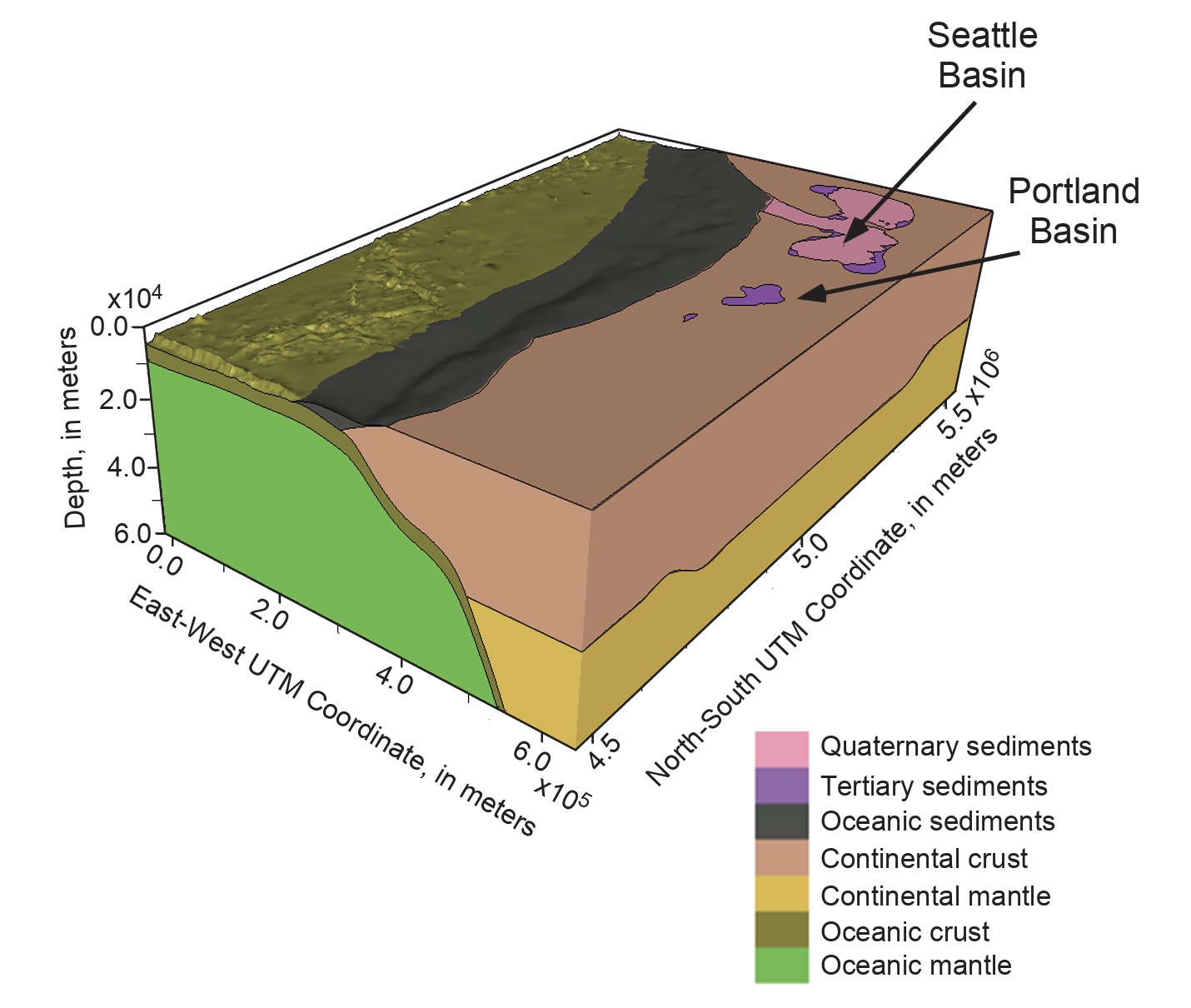
Figure 1:Geologic model volume including the Cascadia subduction zone. VP and VS property models cover the region from 40.2° to 50° N. latitude, 122° to 129° W. longitude, and from 0- to 60-km depth. Location of Seattle and Portland basins shown by arrows. Axes are annotated in Universal Transverse Mercator (UTM) zone 10 coordinates. Bathymetry (GEBCO, 2015) is included while topography above mean sea level (0 m) is excluded. Model projected into UTM zone 10 north coordinates, World Geodetic System 1984 (WGS84) datum. View shows the seven basic geology-based model units and their relationships at depth. Cascadia subduction fault surface is inferred along top of oceanic crust model unit.
Summary
In support of earthquake hazard studies and ground motion simulations in the Pacific Northwest, three-dimensional P- and S-wave velocity (VP and VS, respectively) models incorporating the Cascadia subduction zone were previously developed for the region encompassed from about 40.2°N. to 50°N. latitude, and from about 122°W. to 129°W. longitude. This report describes updates to the Cascadia velocity property volumes of model version 1.3 (V1.3), herein called model version 1.6 (V1.6). As in model V1.3, the updated V1.6 model volume includes depths from 0 kilometers (mean sea level) to 60 kilometers, and it is intended to be a reference for researchers who have used, or are planning to use, this model in their Earth science investigations. To this end, it is intended that the VP and VS property volumes of model V1.6 will be considered a template for a community velocity model of the Cascadia region as additional results become available. With the recent and ongoing development of the National Crustal Model, we envision any future versions of this model will be directly integrated with that effort.
Model Information
SUMMARY: P- and S-wave Seismic Velocity Models Incorporating the Cascadia Subduction Zone (Decimated with a Factor of 5)
MODEL TYPE: V and V
MINIMUM LONGITUDE: -130.1
MAXIMUM LONGITUDE: -121
LONGITUDE RESOLUTION: 1
MINIMUM LATITUDE: 40.2
MAXIMUM LATITUDE: 50
LATITUDE RESOLUTION: 1
MINIMUM DEPTH: 0 km
MAXIMUM DEPTH: 60 km
- Stephenson, W. J., Reitman, N. G., & Angster, S. J. (2017). P- and S-wave velocity models incorporating the Cascadia subduction zone for 3D earthquake ground motion simulations, Version 1.6—Update for Open-File Report 2007–1348. In Open-File Report. US Geological Survey. 10.3133/ofr20171152