McCrory et al. (2012)
Juan de Fuca slab geometry and its relation to Wadati-Benioff zone seismicity
Patricia A. McCrory, J. Luke Blair, Felix Waldhauser, and David H. Oppenheimer

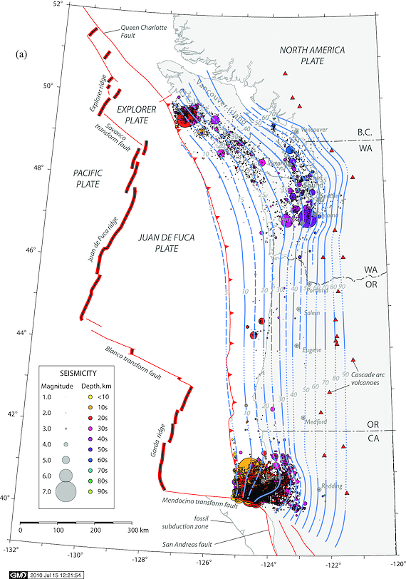
Figure 1:Map showing hand-contoured model of the Juan de Fuca slab surface (see text for description) and seismicity (ANSS, 1975–2009; CNSN, 1985–2009) located beneath the modeled surface. Solid lines denote depth contours in 10 km increments, long dashed lines denote supplemental depth contours in 5 km increments; short dashed lines denote interpolated contours where control points are more than 50 km apart. Note that Wadati-Benioff zone seismicity mainly occurs in regions where slab model arches along strike.
Summary
A new model of the subducted Juan de Fuca plate beneath western North America allows first-order correlations between the occurrence of Wadati-Benioff zone earthquakes and slab geometry, temperature, and hydration state. The geo-referenced 3D model, constructed from weighted control points, integrates depth information from earthquake locations and regional seismic velocity studies. We use the model to separate earthquakes that occur in the Cascadia forearc from those that occur within the underlying Juan de Fuca plate and thereby reveal previously obscured details regarding the spatial distribution of earthquakes. Seismicity within the slab is most prevalent where the slab is warped beneath northwestern California and western Washington suggesting that slab flexure, in addition to expected metamorphic dehydration processes, promotes earthquake occurrence within the subducted oceanic plate. Earthquake patterns beneath western Vancouver Island are consistent with slab dehydration processes. Conversely, the lack of slab earthquakes beneath western Oregon is consistent with an anhydrous slab. Double-differenced relocated seismicity resolves a double seismic zone within the slab beneath northwestern California that strongly constrains the location of the plate interface and delineates a cluster of seismicity 10 km above the surface that includes the 1992 M7.1 Mendocino earthquake. We infer that this earthquake ruptured a surface within the Cascadia accretionary margin above the Juan de Fuca plate. We further speculate that this earthquake is associated with a detached fragment of former Farallon plate. Other subsurface tectonic elements within the forearc may have the potential to generate similar damaging earthquakes.
Model Information
SUMMARY: Juan de Fuca slab
- McCrory, P. A., Blair, J. L., Waldhauser, F., & Oppenheimer, D. H. (2012). Juan de Fuca slab geometry and its relation to Wadati‐Benioff zone seismicity. Journal of Geophysical Research: Solid Earth, 117(B9). 10.1029/2012jb009407