Journeau et al. (2026)
OBS Data Mining Reveals Seismic Structure and Dynamics of the Oceanic Blanco Transform Fault, Northeast Pacific
Cyril Journeau, Amanda M. Thomas, Rachel E. Abercrombie, Brenton W. Hirao, Mingqi Liu, Václav Kuna

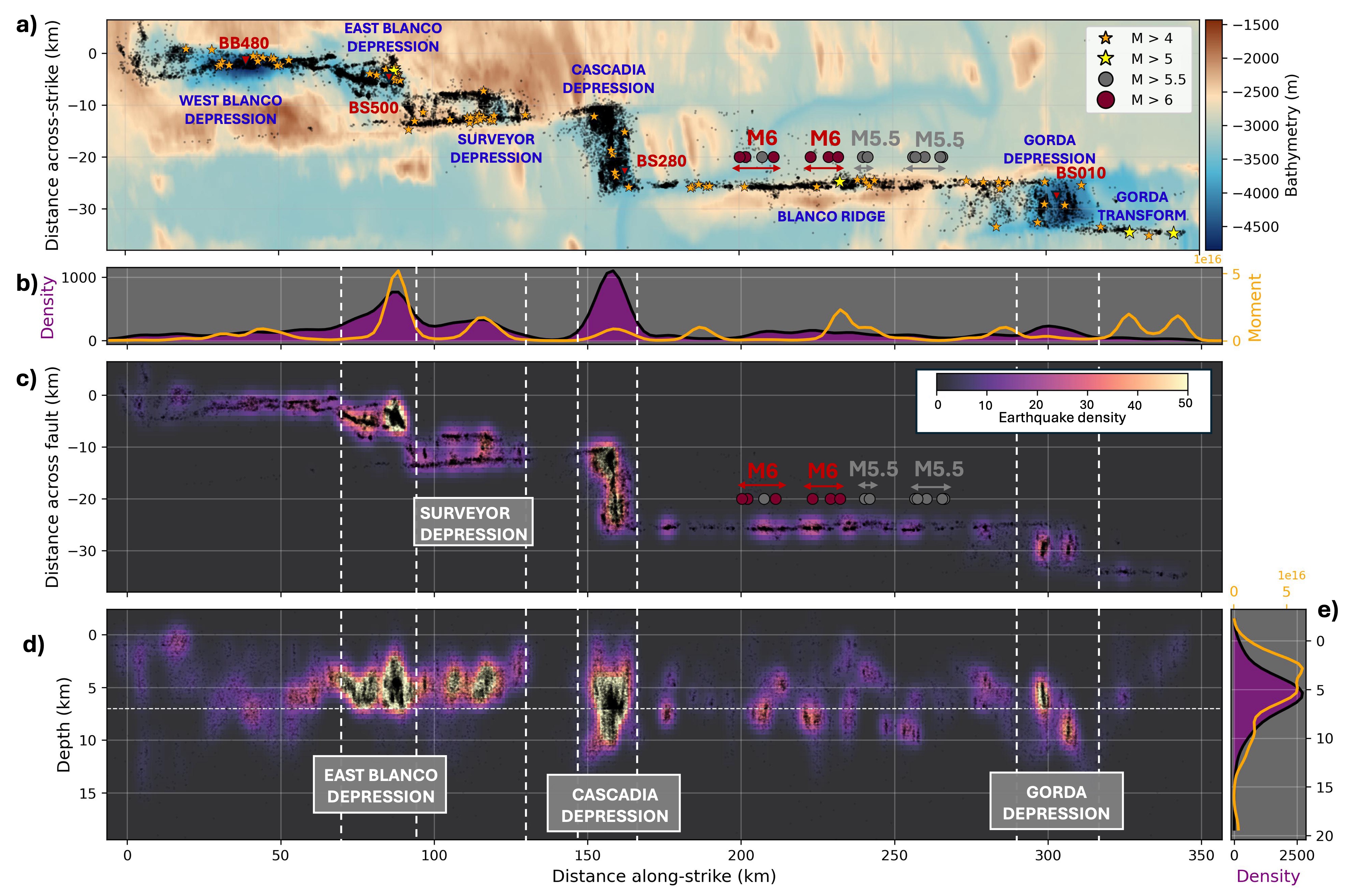
Figure 1:Along‐strike segmentation of Blanco fault system and earthquake catalog variations (a) Along‐strike vs. across‐strike projection of high‐resolution seismic catalog on top of bathymetric map,(b) Along-strike variation of the earthquake density (purple filled curve) and spatial seismic moment integral (orange curve). (c) Map representing the 2D (along‐strike distance against across‐strike distance) variations of the earthquake density. (d) Same as (c) with 2D along‐strike against depth variations. The four step‐over of BTF (EBD, SUD, CAD, and GD) are highlighted with gray rectangles. A vertical exaggeration of 3.5 is applied in (d). (e) Same as (b) but along‐depth.
Summary
Deformation along oceanic transform faults is partitioned between seismic and aseismic slip, controlled by lithology, thermal structure, and fluid circulation. We analyze one year of data from a 54‐station ocean bottom seismometer network deployed across the Blanco Transform Fault (BTF), Northeast Pacific. Using machine‐learning pickers and high‐precision location methods, we construct a high‐resolution microseismicity catalog with over 30,000 earthquakes. Comparison with three independent catalogs shows that earthquake depth estimates vary with velocity models, phase association, and location strategies. Our enhanced catalog reveals strong along‐strike variations in seismicity, including depth extent, density, and moment release. Seismicity concentrates near structural step‐overs, which host ∼2.4 times more earthquakes than intervening transform segments, indicating segmentation of the fault system. Four‐dimensional spatiotemporal patterns highlight marked contrasts between transforms and step‐overs. Extension at step‐overs likely enhances fluid circulation within networks of normal faults, sustaining high microearthquake rates and seismic bursts. Comparison with three‐dimensional thermal models constrains the nature and thermal state of the BTF step‐overs, classifying them as intra‐transform spreading centers (ITSCs) or amagmatic pull‐apart basins. Along the Blanco Ridge segment, we compare space–time patterns of microseismicity with relocated M > 5.5 earthquakes from 1992 to 2019. Three rupture barriers exhibit distinct levels of microearthquake activity, while active seismic bursts in the mantle are concentrated beneath locked M6 patches and one rupture barrier. A crustal northeastward fault bending is observed on the edge of a locked M6 patch. Our results highlight how fault geometry, thermal structure, and fluid‐related processes jointly control seismicity patterns and slip behavior on oceanic transform faults.
Catalog Summary
REGION: Blanco Transform Fault
TIME SPAN: 2012-09-24 to 2013-10-03
EVENT TYPE: Earthquakes
NUMBER OF EVENTS: 30,447
DETECTION METHOD: PickBLue ML OBS picker
ASSOCIATION METHOD: PyOcto
LOCATION METHOD: NonLinLoc-SSST
VELOCITY MODEL: From Christeson et al. (2010)
MAGNITUDE TYPE: Local magnitude
- Journeau, C., Thomas, A. M., Abercrombie, R. E., Hirao, B. W., Liu, M., & Kuna, V. (2026). OBS Data Mining Reveals Seismic Structure and Dynamics of the Oceanic Blanco Transform Fault, Northeast Pacific. Journal of Geophysical Research: Solid Earth, 131(6). 10.1029/2025jb032982
- Christeson, G. L., Karson, J. A., & McIntosh, K. D. (2010). Mapping of seismic layer 2A/2B boundary above the sheeted dike unit at intermediate spreading crust exposed near the Blanco Transform. Geochemistry, Geophysics, Geosystems, 11(3). 10.1029/2009gc002864